Landscapes - People - Global change

Category: Maps (Page 2 of 4)

ESRI Canada ‘App of the Month’

McNally's Ferry - erstwhile town and transportation infrastructure on the Saint John River, pre-Mactaquac Dam and today.

McNally’s Ferry – erstwhile town and transportation infrastructure on the Saint John River, pre-Mactaquac Dam and today.

Congratulations to MREM alum Larissa Holman, for news that our Before the Mactaquac Dam storymap was selected as ESRI Canada’s App of the Month for October (French version here).  Larissa worked with me back in 2015 supported by Energy Transitions (Parkins PI) SSHRC funding.  Larissa is now working with Ottawa Riverkeepers, and reports that her job:

… is a nice mix of keeping on top of projects, investigation work when someone reports pollution or odd activity on the river, working with some really wonderful and knowledgeable volunteers and the occasional canoe trip or boat ride out on the river.

A great alum story for a lovely fall day.

Meeting at Carleton’s Fahrig Lab

A diversity of scholars hard at work at Carleton on issues of sustainable agricultural landscape patterns and ecosystem services.

A diversity of scholars hard at work at Carleton on issues of sustainable agricultural landscape patterns and ecosystem services.

Thanks to Lenore Fahrig and her team at Carleton, as well as funding from NSERC, for the opportunity to participate yesterday in a meeting of minds about sustainable agricultural landscapes and ecosystem services. Significant snowfall created a cloistered feel and a productive mindset. While numbers were dominated by ecologists, agricultural and spatial scientists from universities, government and NGOs, it was a welcoming and collaborative environment, and ideas about the integration of social science research and stakeholder engagement were greeted enthusiastically.

Congratulations Yan Chen

Yan Chen, MES 2016

Yan Chen, MES 2016

Yan Chen defended her innovative SSHRC- and NSGS-funded MES thesis masterfully on Friday. She gleaned youth landscape values from a year’s worth of Instagram images from a 5-km radius of the actual and proposed headponds, respectively, of the Mactaquac and Site C dams. Being the first defense since a large new class of MES students started in the fall, the room was packed with supporters. Committee member John Parkins skyped in from the University of Alberta, and Faculty of Management colleague Jennifer Grek-Martin examined the thesis, which included wide-ranging discussions on landscape, sense of place, aesthetics, digitalism (our new religion as described by Yuval Harari), and virtual/augmented reality. It was everything you hope a defense can be: Yan spoke strongly in support of her work, and creatively about its potential implications and improvements. I look forward to getting her papers out in the literature, and building on it with a SSHRC Insight Grant that went in on Monday, led by colleague and expert in making Big Data matter, Mike Smit.


Miller’s Valley and more

A particularly beautiful book cover eased the hesitation at buying hardcover.

A particularly beautiful dust jacket eased my hesitation at buying hardcover.

A Saturday Globe review for Miller’s Valley caught my eye, and when I discovered I was 46th in line to borrow the book at the Central Library, I headed to the marvellous independent bookstore Westminster Books during a weekend trip to Fredericton to buy my own copy. The book tracks the coming of age of a girl in Pennsylvania as she watches government pressure inexorably lead to the inundation of her family’s farm for the ‘public good’. The flooding plays the same role in this book as in many others I’ve discussed here and in recent papersshorthand for obliteration, loss, injustice, and forgetting – but what distinguishes it is in demonstrating the capacity to adapt over time, nonetheless. A few excerpts from the last page resonate particularly:

I don’t really miss the Miller’s Valley I used to know, the one in which I grew up, my very own drowned town. It’s been gone a long time now… They’re talking about having a big celebration for the fiftieth anniversary… and that’ll clinch it. If something’s been around fifty years, it’s been around forever. Most people think it’s always been there. They run fishing boats and go ice skating and sit in folding chairs and look out over the place where we all lived and it’s just water to them, as far as the eye can see. I guess it’s just water to me, too. … When I talked to Cissy about Andover, when I was a kid, I thought her life, her past, her childhood, all of it was buried down there under the water. I didn’t understand that it was above the surface, in her, the way mine is in me. … Lots of people leave here, that’s for sure, but people stay, too. And some are like me. They circle back. (p. 256-7)

Hand-drawn map by Joe George of a transect from the Woolastook campground in NB over old homesteads flooded by the Mactaquac Dam.

Hand-drawn map by Joe George of a transect from the Woolastook campground in NB over old homesteads flooded by the Mactaquac Dam.

In this same weekend I visited Joe George at COJO Exploration, who had spent the day scuba diving in his quest for the old townsite of Kingsclear, now under the Mactaquac headpond. His hand-drawn map from the dive shows the foundations, wells and other infrastructure he swam over, trying to avoid stirring up sediment in the low-visibility (2 ft) conditions. Looking at old maps, he reckons the well (“still water in it!”, he joked) belonged to the Long family. Joe is hoping to set up a recreational scuba track – as he showed me, basically a high-viz yellow cable – to allow visitors to explore the drowned town. He also hopes, however, to find some relics of life there, to share with either prior residents or local museums.

Dams are in the news, either in terms of removal (see a discussion here about opening the gates of the Glen Canyon Dam), or protests about construction. For instance, a public letter signed by Canadian scholars protests about Site C’s approval as a violation of process and treaty rights. An early-stage proposal for a dam on the Eldred River near Powell River BC is being protested by rock climbers (on the basis of a long-standing base camp) and foresters (the transmission infrastructure associated with independent power installations affects forestry and thus jobs), possibly the first time that those two bodies were on the same side of any issue.

Uncharted

Aiden and Michel's (2013) book reveals how big data can help us understand how culture has changed.

Aiden and Michel’s (2013) book reveals how big data can help us understand how culture has changed.

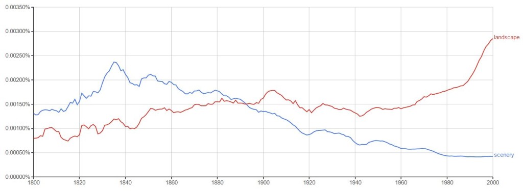
I pulled this book, Uncharted (2013), by Erez Aiden and Jean-Baptiste Michel, out of a bargain bin at Chapters a few weeks ago, and it is another example of serendipity. These Harvard PhDs collaborated with Google’s book digitization project to develop the Google Ngram tool. They liken their project to a tool to a microscope or telescope, which were tools that brought new dimensions to view for scientists. Their culture-scope is able to track uses of terms or phrases over time within Google Books’ enormous and growing database of digitized literature. They coined the term ‘culturomics‘, which is too awkward to stick, but the value is clear. Watch the holistic idea of ‘landscape’ overtake the aesthetically driven ‘scenery’ around the turn of the last century (below). Lots of food for thought in a world of Big Data.

Google Ngram View of landscape versus scenery in English text corpus, 1800 to 2000.

Google Ngram View of landscape versus scenery in English text corpus, 1800 to 2000.

« Older posts Newer posts »

© 2024 Kate Sherren

Theme by Anders NorenUp ↑